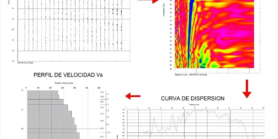
When our field crew sets up the 24-channel seismograph across a site in Aurora, the first thing we account for is the glacial stratigraphy that defines this part of the Fox River Valley. A linear array of 4.5 Hz geophones, spaced between 2 and 5 meters depending on target depth, captures surface-wave dispersion data that we process into a one-dimensional Vs profile. The active-source method lets us generate Rayleigh waves with a sledgehammer and plate, reaching depths of 30 meters reliably—exactly what the International Building Code requires for Site Class determination. In Aurora, where the surficial geology shifts from silty clay till near downtown to outwash sands and gravels west of Randall Road, the Vs30 value can vary by over 200 m/s across a single subdivision. We run multiple spreads per site to catch that variability before the structural engineer locks in the seismic design category. For deeper bedrock mapping, we often pair the survey with a seismic refraction line to resolve the top-of-rock interface where the MASW dispersion curve loses resolution.
Vs30 alone dictates the seismic design category—a 50 m/s shift in average velocity can change the base shear coefficient by 15% or more in Aurora's Site Class D soils.
Technical details of the service in Aurora Illinois
Local geotechnical conditions in Aurora Illinois
The freeze-thaw cycles that hit Aurora from November through March create a near-surface velocity anomaly that inexperienced operators mistake for stiff soil. When the top 0.5 to 1 meter is frozen, Rayleigh-wave phase velocities at high frequencies jump artificially, and if you do not mask those frequencies during inversion, your Vs30 comes out 10–15% too high—pushing a Site Class D profile into Class C territory and under-designing the lateral system. Our protocol during cold-weather surveys includes a shallow temperature probe and, when frost is present, we increase the source offset and filter the dispersion curve above 40 Hz. Summer brings the opposite challenge: saturated silty clays in the former glacial lake plain soften and reduce Vs, so we schedule surveys when groundwater is at seasonal average, avoiding the weeks right after heavy rain events that swell the Fox River. In areas near the Indian Creek floodplain on Aurora's far west side, we also check for liquefaction susceptibility using the Vs profile and soil behavior type index, particularly where the mapped water table is shallower than 3 meters.
Our services
Every MASW survey we run in Aurora includes field acquisition, dispersion analysis, inversion modeling, and a stamped engineering report with Vs30 and Site Class. We also offer these supporting services for comprehensive site characterization:
Combined MASW + Seismic Refraction
Pair surface-wave and body-wave methods to resolve both Vs layering and top-of-rock depth. Useful where the Sandwich Fault Zone creates abrupt bedrock offsets across the property.
Downhole Seismic (ASTM D7400)
Borehole-based Vs measurement for direct velocity profiling below 30 meters. Run in conjunction with SPT drilling when the geotechnical investigation requires both N-values and dynamic soil properties at depth.
Site-Specific Ground Motion Analysis
One-dimensional equivalent-linear site response using DEEPSOIL or equivalent software, applying the Vs profile to predict surface spectra for Aurora's design earthquake scenarios per USGS hazard maps.
Common questions
How much does a MASW / VS30 survey cost for a typical commercial lot in Aurora?
For a standard commercial lot in Aurora requiring two to three geophone spreads and active-source acquisition to 30 meters, the survey typically ranges from US$1,830 to US$2,810. The final cost depends on site access, number of spreads needed to capture lateral variability, and whether passive-source recording is added to extend depth beyond 30 meters. Each survey includes full dispersion processing, inversion modeling, a Vs30 calculation, and a signed engineering report with Site Class determination per ASCE 7-22.
What is the difference between MASW, downhole, and crosshole shear wave testing?
MASW is a surface-based method that records Rayleigh-wave dispersion along a geophone array and inverts it to obtain a 1D Vs profile—no borehole required. Downhole testing uses a borehole with a source at the surface and a receiver lowered incrementally, measuring direct arrival times. Crosshole testing requires two or more boreholes and measures wave travel between them. MASW is faster and non-invasive, making it suitable for preliminary site classification, while downhole and crosshole provide higher resolution for critical structures but at greater cost and with drilling requirements.
How long does the field work take for a MASW survey in Aurora?
Field acquisition for a single spread takes about 45 to 90 minutes, including geophone layout, source impacts at multiple offsets, and quality-checking the dispersion image in real time. A typical commercial site with two to three spreads is completed in half a day. Data processing and report preparation require an additional two to three business days. During winter months in Aurora, frozen ground may require extra source energy and longer offsets, adding roughly 30 minutes per spread.
Does the City of Aurora accept MASW results for building permit site classification?
Yes, the City of Aurora Building Division accepts MASW-derived Vs30 values for IBC Site Class determination as part of the geotechnical report package submitted with permit applications. The survey must be performed and stamped by a licensed professional engineer and must comply with ASCE 7-22 procedures. We include the full dispersion curve, inversion parameters, and Vs column in the report so the plan reviewer can verify the Site Class assignment directly.